& Construction
Integrated BIM tools, including Revit, AutoCAD, and Civil 3D
& Manufacturing
Professional CAD/CAM tools built on Inventor and AutoCAD
Geotechnical engineering is a multidisciplinary field combining principles of soil mechanics, rock mechanics, groundwater, geology, and engineering to solve complex challenges related to ground behavior and construction. Geotechnical engineering is a subset of civil engineering.
Geotechnical engineers are indispensable in construction projects for several reasons. They ensure safety by evaluating subsurface conditions, avoiding risks like soil instability and slope failures, and providing recommendations to civil engineers for design and construction details. Their expertise in civil engineering design guarantees the structural integrity of buildings, public infrastructure, and site development and minimizes potential project impacts, cost impacts, or infrastructure failures by addressing issues early.
Geotech engineers navigate complex regulations, provide engineering and construction recommendations based on existing ground conditions, and optimize designs for specific site conditions. Mitigating financial and operational risks, they improve the project’s success, long-term performance, and public trust. In essence, geotechnical engineering plays a pivotal role in safe, efficient, and resilient construction, tailoring solutions to the unique challenges of each site.
There are several key parts of geotechnical engineering:
Geotechnical investigation involves inspection of subsurface conditions (boring logs, ground inspection and monitoring, and soil testing) to determine the characteristics, stability, and physical properties of areas of rock and soil.
Geotech engineers evaluate and recommend improvements to the ground surrounding construction and infrastructure, stabilizing slopes to prevent movement or settlement and reinforcing foundations.
Determining how a structure, roadway, or railway will affect the ground it sits on (and vice versa), then designing the infrastructure’s foundation accordingly is a key aspect of geoengineering.
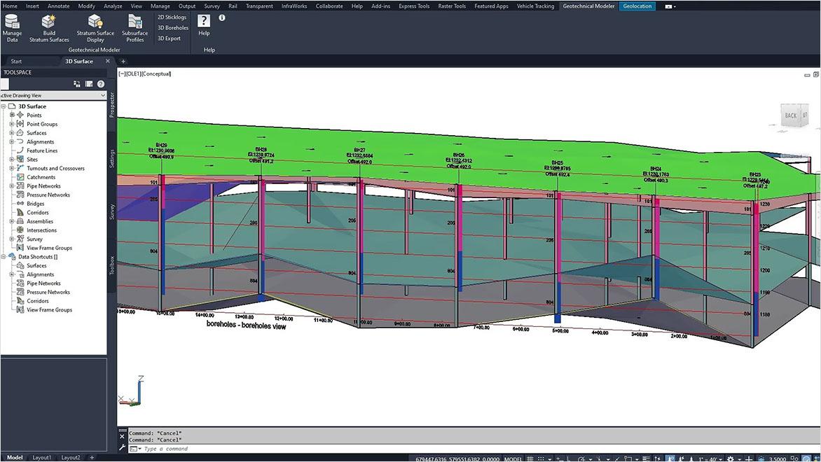
Software and technology have revolutionized advanced geotechnical engineering by simplifying tasks, boosting performance, and enhancing precision. Efficient data collection and analysis from soil tests and borehole logs aids informed decision-making.
Geographical information systems (GIS) assist in visualizing site features, while numerical modeling software allows geotechnical engineers to simulate intricate behaviors such as soil-structure interactions and slope stability.
Remote sensing tools such as drones, ground sensors, and satellites provide detailed site information, while automated monitoring systems and sensors offer real-time data on soil movements and structural behaviors. Collaboration is improved through cloud-based platforms, and documentation and reporting are more streamlined.
Provided that geotech engineers have a solid foundational understanding to effectively utilize these tools, the technology optimizes efficiency, accuracy, communication, and risk management.
Geotechnical engineering software offers a range of benefits that enhance the efficiency, accuracy, and effectiveness of various tasks within the field:
Geotechnical software helps organize vast amounts of geotechnical data, including soil properties, test results, and geological information. And, geotechnical design software integrates with other engineering software for seamless data sharing and collaboration.
Geotechnical software often provides 3D modeling and visualization capabilities, allowing geotech engineers to create realistic representations of subsurface conditions and soil layers.
Geotechnical analysis software helps assess potential risks associated with soil stability, liquefaction, settlement, and other geotechnical hazards. Engineers can simulate scenarios before construction begins.
Some geotechnical software includes GIS capabilities, allowing engineers to incorporate geographic and spatial information into their analysis.
Geotechnical software generates detailed reports, including graphical representations of analysis results, design parameters, and recommendations. This aids in communication with clients, regulatory bodies, and teams.
Geotechnical engineering often requires adherence to specific regulations and standards. Geotechnical software can incorporate these guidelines, ensuring that designs meet the required codes and regulations.
Powerful BIM and CAD tools for designers, engineers, and contractors, including Revit, AutoCAD, Civil 3D, Autodesk Forma, and more
Geotechnical engineering has been around for hundreds of years, and new talents and minds are always needed to advance the field. Autodesk is helping to support this by offering free educational licenses for our geotechnical software to students and educators, so they can access the same tools used by professionals working in the field. Renewable 1-year subscriptions are available for all of our top products, such as Civil 3D.
Building information modeling (BIM) enables engineers to create and manage information about an asset digitally across its lifecycle. In geotechnical engineering, it can be used to visualize ground conditions in a design context and to enhance collection and sharing of data collaboratively. BIM geotechnical engineering analysis software can help streamline workflows, enhance understanding of site conditions and obstacles through geotechnical testing, and reduce the need for real-world exploration. Find out more in our article Geotechnical BIM: Applying BIM Principles to the Subsurface.
JACOBS
Leading technical consultancy brings stormwater management plan to life with Civil 3D, Infraworks, and 3ds Max.
Image courtesy of Jacobs
THOMAS AND HUTTON
Engineering firm reaches green building goals with AutoCAD and Civil 3D.
WDI STUDIOS
Architecture and interior design studio keeps complex site development project on track.
Autodesk’s popular 3D civil design software, Civil 3D, has an extension designed specifically for geotech engineering: the Geotechnical Modeler. This extension gives you the capability to visualize and analyze geotechnical data within the Civil 3D environment. In addition to being able to import and connect data as needed, you can create subsurface visualizations, add subsurface profiles, create surfaces within your Civil 3D designs, export subsurface model data, and more. Find out more about these geotechnical software capabilities and benefits in our “Have You Tried” article on the Geotechnical Modeler.
See how reality capture and 3D modeling are laying the foundation for the future of the Glen Canyon Dam.
Explore the impact of geotechnical engineering infrastructure projects on Medellín, one of Colombia’s most vulnerable communities.
See how the Chongqing Architectural Design Institute of China delivered a multilayered solution with BIM.
Geotechnical engineering is a specialized branch of civil engineering. It focuses specifically on the behavior of earth materials, such as soil and rock, as they interact with structures and infrastructure. Geotechnical engineering plays a crucial role in the design, construction, and maintenance of civil engineering projects, including buildings, bridges, roads, dams, tunnels, and more.
Civil engineering is a broad field that encompasses various sub-disciplines, and geotech engineering is one of them. Other sub-disciplines within civil engineering include structural engineering, transportation engineering, environmental engineering, water resources engineering, and more.
Geotechnical engineering finds applications across numerous domains, playing a pivotal role in ensuring the stability, safety, and effectiveness of projects. From designing foundations for structures and analyzing slope stability to creating earthquake-resistant infrastructure and underground tunnels, geotechnical engineers contribute expertise in understanding soil and rock behavior.
They’re essential in the design of retaining walls, ports, roads, dams, bridges, railways, buildings, grading sites, and waste disposal systems, while also monitoring and mitigating soil erosion and groundwater contamination risks. Geotechnical engineering aids in making informed decisions about construction site suitability, contributes to environmental impact assessments, and fosters research for innovative techniques.
GIS (geographical information systems) and BIM (building information modeling) technologies are used for different purposes. GIS focuses on managing geographic and spatial data for tasks such as mapping, analyzing transportation networks, and environmental management. BIM, on the other hand, creates detailed 3D models of buildings and infrastructure, encompassing architectural, structural, and systems-related information.
While GIS deals with spatial relationships and geographic data, BIM is centered on building components and systems, serving the needs of the architecture, engineering, construction, and operations (AECO) industries. Despite differences, there can be overlap when dealing with geospatial aspects of construction and geotechnical engineering projects.
Autodesk provides a range of software solutions with geographic information system (GIS) capabilities, including AutoCAD Map 3D. This software is designed for creating, managing, and analyzing the spatial data used for tasks involving geographic information, maps, and geospatial databases. AutoCAD Map 3D encompasses features such as data integration, visualization, analysis, and mapping tools. It helps geotech engineers and others seamlessly incorporate GIS data such as shapefiles, geodatabases, and satellite imagery into their design-and-analysis workflows, making it a staple in industries such as utilities, transportation, urban planning, and environmental management.